Mount Obama
Level: Easy/ Moderate
Duration: 1 to 3 hrs
Elevation: 300 mtrs
Mount Obama (ex Bogey Peak) is the highest point on Antigua and can be climbed from its southern or northern side. Its is not a climb to speak of, but more a stroll up the hill. The summit is fenced off and crowned by a very noticeable AT&T telecom antenna; views are nil unless you manage to get inside the antenna compound, a rare feast as the telecom complex is hardly ever manned and the gates are locked.
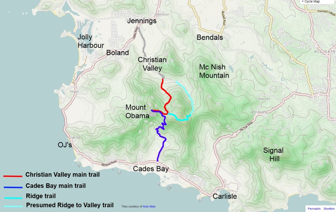
Mount Obama is now a National Park and a few great jungle trails have been opened on the north side of the mountain, leading to the summit and beyond.
From the South (Cades Bay)
From the south side, the AT&T dirt and partially cemented road climbs to the summit. It starts off close to Cades Bay. Coming from Fig Tree Drive, Falmouth or the village of Swetes, you will first go through the settlement of Old Road. A few kilometers beyond, as you reach Cades bay, a dirt road turns inland just before a very large pineapple plantation. The turnoff is not sign posted, but if you pass gates on the right side of the main road decorated with plaster pineapples, you have gone too far.
The road starts of as dirt track, with some occasional remains of paving. It is just passable in a normal car. You will eventually reach the concrete road, and the ATT sign advising that this is private turf. In true Obama spirit, dont let it deter you from visting Antigua's highest point!
Park here; the gradient is in any case too steep for non 4x4 vehicles, and it is easier just to walk up the hill following the main road. You should reach the summit in a little more then half an hour. As the road levels off on the summit ridge, you will notice a distinct trail marked with red and blue ribbons on the trees, turning off to the right along the ridge. This is where the official Mount Obama hiking trail meets the main road to the summit.
From the North side (Christian Valley):
The hike up from the north side is a whole lot more interesting. The trail starts by the mount Obama National park monument; to reach it take the road up Christian valley, accessed from the village of Jennings, off Valley road linking Jolly Harbour to St John's. This is a well maintained dirt road, leading to agricultural grounds.
Leave the car (or bike?) at the picnic area and walk along the clear track towards the mountain, through a beautiful and well maintained mango orchard. You will soon spot the blue and red markings ribbons tied to the trees as you penetrate the forest. A marked trail leads to the left off the main track with a small rope to help people down a gully. Ignore it and wallk straight on, crossing the first stream. You are now in the rainforest. The trail is easily followed, goes past some magnificient giant bamboo clusters and meanders upwards following creeks and ridges. This is a great jungle walk, easy but very evocative.
You will reach the mountain ridge in less then 45 minutes. Take a right hand turn at the trail cross road on the ridge and you will soon find yourself on the cemented road to the summit, 15 minutes away.
On the way back, instead of taking the same track back down, you can follow the ridge trail the other way, going along the Shackerley range main ridge in an easterly direction. This trail is also well marked and easy to follow. After less then half an hour's walk and crossing a few lemon grass fields, you will start to descend down a steep gully. This trail, still marked with blue and orange/red ribbons, should bring you back to Christian valley.
Note that I have not completed the downhill section of the second part of this walk all the way. The trail is well marked along the ridge and downhill, and although all indications seem to show that it returns to the Mount Obama monument, this still needs to be confirmed. My car was parked on the Cades Bay side, and I had already done a South and North climb and was too lazy to do a third consecutive descent/ascent!! So you might just have to backtrack if I am wrong and think of me in endearing terms.... Feedback from adventurous spirits to update this is very much sought and welcome.