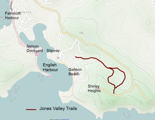
Jones' Valley Trails
Duration : 40 minutes each way
Level : Easy
Elevation : 150 meters
Level : Easy
Elevation : 150 meters

These two easy trails up to Shirley Heights share the same starting and finsihing points, along the road to Galleon beach and close to the ruins of the infirmary up at Shirley's. They split at about a quarter of the way on and rejoin at about the ¾ mark; one follows the north side of the Jones valley, the other...the southern one. These trails are totaly boring view wise, as they are enclosed in low foresty shrub, but seem to attract quite a few people nevertheless... Maybe walking in the shade of the forest is a small positive compensation for the lack of view. The trails are well marked and defined, you will not get lost -even if you deserve to.
The start of the trail is sign posted on the Galleon beach road, and follows a dry river bed for the first few hundred meters. This is the 'adventure' bit, where you have sometimes to chose your own way up the boulders. You will soon reach the remains of a small dam and watermill, where the trail splits. Left takes you up via an old British graveyard, but is slightly longer. Right takes you up the hill in a more direct way...consider a loop walk? In any case, a further 20 minute or so walk will bring you to the main road close to Shirley Height, where you can chose one of the other better trails for the return journey.
The start of the trail is sign posted on the Galleon beach road, and follows a dry river bed for the first few hundred meters. This is the 'adventure' bit, where you have sometimes to chose your own way up the boulders. You will soon reach the remains of a small dam and watermill, where the trail splits. Left takes you up via an old British graveyard, but is slightly longer. Right takes you up the hill in a more direct way...consider a loop walk? In any case, a further 20 minute or so walk will bring you to the main road close to Shirley Height, where you can chose one of the other better trails for the return journey.