Mount McNish
Duration: 1 to 2hrs from Jennings village (ride or walk)
Distance: 65 km loop ride from Falmouth via Fig Tree, Bendals and the ponds
Level: Moderate
Elevation (Mt McNish): 330 mts
Distance: 65 km loop ride from Falmouth via Fig Tree, Bendals and the ponds
Level: Moderate
Elevation (Mt McNish): 330 mts
This is the third highest summit in Antigua, crowned like all the others by yet another telecom antenna. A fairly steep track driveable by 4x4 leads to the top, easily rideable or walkable through some nice scenery. The area is quite remote (at least by Antiguan standards). The start of the track is a bit hard to find, but hey, that's what this page is for.
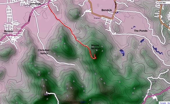
Coming from Jolly Harbour and Old Road, you will arrive in Jenning's Village from the southern end. The main road going through Jennings is more or less straight, and turns off to the left at the northern end of the village with a minor road continuing straight on. Take a right on a non descript small village road just before you reach this junction; there is a small supermarket on the corner.
This side road leads off in an easterly direction away from the village, and soon turns into what looks a bit like an ancient causeway on some flatlands. Dodge the cows and keep going towards a valley in a south easterly direction. The trail will soon start climbing; the way up to the summit is pretty obvious. Once you get close to the top, a turn off to the left leads to what must have been once one of the highest sugarcane mills in Antigua.
Coming close to the mountain top, the forest clears and gives way to lemon grass fields, offering an excellent view of most of the island. The hill top itself is perfectly cleared of vegetation, offering a great view on the Watershed Pond Valley, St Johns and the Five Island Peninsula.
A number of bulldozers, diggers and caterpillars were running wild on the hill side at my last vist, opening new roads at unrealistic – not to say mad- gradients and angles. It is possible that these untamed machines have since opened a track linking the old windmill to Bendalls Village and the Watershed Valley beyond, through the lemon grass fields (nearly impossible to cross otherwise), in which case walking or riding down on that side of the hill might be a good option for the return route. For those trying this in a 4x4, avoid going down anything you can not climb back out of; it might sound kind of obvious but could be helpful free advice for those with willies bigger then brains...some of the gradients are close to 30%. on very lose soil.