Antigua Outdoors
  • Home
  • Antigua
  • Cycling
    • Around Falmouth Harbour >
      • Shirley Heights
      • Shirley to Indian creek
      • Monk's Hill
      • Rendez vous bay
      • The Donkey Loop
    • Island wide >
      • Cycling to St John's
      • The Big Loop: Fig Tree, St John's, Potswork dam
      • Devil's Bridge & Long Bay
      • Harmony Hall & Half Moon Bay
      • The other way to St John: Bendals to Swetes via the Body Pond Valley
      • Mount McNish
      • The North Coast
      • Five Island Peninsula
  • Hiking
    • The Goat Track (Middle Ground trail)
    • Monk's Hill
    • Walks around Shirley Heights >
      • Shirley Height main road
      • Desmond's and Carpenter's trails
      • Jone's Valley Trail
    • Sugar Loaf Hill
    • Wallings dam walks >
      • Wallings Dam to Signal Hill
      • Wallings Dam to Rendez-vous Bay and Falmouth
    • Mount Obama
    • Mount McNish
    • West Antigua map
  • Activities
  • Time Out
    • Eating Out >
      • Around Falmouth
      • Elsewhere
    • Playing Out
    • Sleeping out
  • Beyond!
    • The Kingdom of Redonda
    • Montserrat
  • Feedback

Desmond's & Carpenter trails

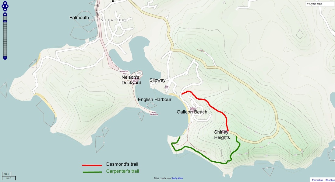
Desmond's and Carpenter's trail loop 


Level: Easy
Duration: 1.5 hrs
Elevation: 150 meters  

Picture

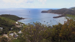
This loop walk up to Shirley Height and back is my absolute favourite in the English harbour area.

The walk starts, like all the trails to Shirley Height at Galleon beach. Walk, drive or take the shuttle tender there from Nelson's Dockyard.

Desmond's trail starts on the main road about a 100 meters before the Galleon beach Callabash resort  gates. It is clearly sign posted; a nice, well defined trail takes you up to Shirley Heights along one of the ridges. The views over English harbour are good and the climb takes at the most half an hour.
Picture

You will arrive on the grassy bank just below Shirley Height restaurant; after rejoining the main car park area, go down the main road about 200 meters till you pass the small graveyard overlooking the sea. Just beyond that a fairly wide track leads to the right towards the  cliffs, to a view point where farmers  have left bath tubs to collect water for the goats.

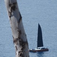
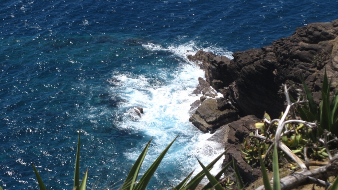
Go close to the edge, where the sharp drop towards the sea starts, look a bit to the right... and you will see the start of the Carpenter's trail meandering down the slope. It is a small trail going down  to the sea side, offering a beautiful view of the cliffs between Shirley heights and Indian creek. The ocean breeze blows here, the Atlantic swell can be heard crashing from high above and the view is one of wild untamed  beauty. A perfect escape.

Picture
You will soon reach the bottom of the slope, where the trail turns back along the sea side towards Galleon beach. On the way you will pass shimmering rockpools at the bottom of the layered cliffside. There is a choice of trails here, the first and the prettiest option following the sea side , well marked with white paint. The other, larger trail is shorter and cuts inland straight back to Galleon beach. 
Follow the shore trail, and you will soon reach fort Charlotte, guarding the Eastern side of the entrance to English Harbour. This is a peaceful spot, where the regatta flag pole is hoisted during races. The track from here back to Galleon beach is very clear; you can also go down onto the shoreside and follow the beach around. In any case you will arrive within the grounds of the Callabash resort, somewhere close to the last villa on the main beach. 

Picture

Walk, drive, cycle, boat or swim back to Nelson Dockyard or Falmouth.
Picture
Picture
For more on Carpenter's trail, try this link to the Antigua Nice website!
Powered by Create your own unique website with customizable templates.
  • Home
  • Antigua
  • Cycling
    • Around Falmouth Harbour >
      • Shirley Heights
      • Shirley to Indian creek
      • Monk's Hill
      • Rendez vous bay
      • The Donkey Loop
    • Island wide >
      • Cycling to St John's
      • The Big Loop: Fig Tree, St John's, Potswork dam
      • Devil's Bridge & Long Bay
      • Harmony Hall & Half Moon Bay
      • The other way to St John: Bendals to Swetes via the Body Pond Valley
      • Mount McNish
      • The North Coast
      • Five Island Peninsula
  • Hiking
    • The Goat Track (Middle Ground trail)
    • Monk's Hill
    • Walks around Shirley Heights >
      • Shirley Height main road
      • Desmond's and Carpenter's trails
      • Jone's Valley Trail
    • Sugar Loaf Hill
    • Wallings dam walks >
      • Wallings Dam to Signal Hill
      • Wallings Dam to Rendez-vous Bay and Falmouth
    • Mount Obama
    • Mount McNish
    • West Antigua map
  • Activities
  • Time Out
    • Eating Out >
      • Around Falmouth
      • Elsewhere
    • Playing Out
    • Sleeping out
  • Beyond!
    • The Kingdom of Redonda
    • Montserrat
  • Feedback